


visit our website for more detail: www.onlinehydrologyeducation.com
One of strongest tropical cyclones on record to roam the North Indian Ocean is approaching the coast of India and Pakistan, where several people have already died and tens of thousands have left their homes.
Cyclone Biparjoy, the equivalent of a Category 2 hurricane, reached its top intensity Tuesday with peak winds around 105 mph (90 knots) in the northeastern Arabian Sea.
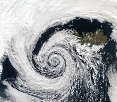
The storm is forecast to make landfall near the border of India and Pakistan around midday Thursday local time, with sustained winds of 80 mph (70 knots), according to the India Meteorological Department. Biparjoy is expected to produce torrential rain, damaging winds and a dangerous storm surge — or rise in ocean water above normally dry land at the coast.
Although Biparjoy grew to Category 2-equivalent strength Tuesday, it is forecast to weaken some as it approaches land because of increasingly hostile high-altitude winds that will disrupt the storm’s organization. When it crosses the coast, its maximum sustained winds are projected to drop to 80 mph (70 knots), or Category 1-equivalent strength.
Cyclone warnings are in effect for the Saurashtra and Kutch coasts of India’s Gujarat state, running from near the border with Pakistan to the Gulf of Khambhat, with storm surge warnings in effect for much of the same zone.


Contact us for any query:
Email us: onlinehydrologyeducation@gmail.com
WhatsApp: +92 3024599827
Follow us on Social Media
*Facebook Page*: https://www.facebook.com/onlinehydrologyeducation
*Twitter:* https://twitter.com/onlinehydrology?t=XglBxnXk2fCcwGhUJesbmw&s=09
*Instagram:* https://www.instagram.com/onlinehydrologyeducation
*Linkedin:* https://www.linkedin.com/company/online-hydrology-education
*YouTube:* https://youtube.com/channel/UC-l8sjuURmXwOnLRue7tSzA
Best Regards:
Online Hydrology Education Team